histoire Published on 12 May 2026
Mulberry B & Gold Beach: Arromanches' Mulberry Harbour
Phoenix caissons, floating piers, the June 1944 storm: the story of the Mulberry B harbour and our tips for spotting its remains at low tide.
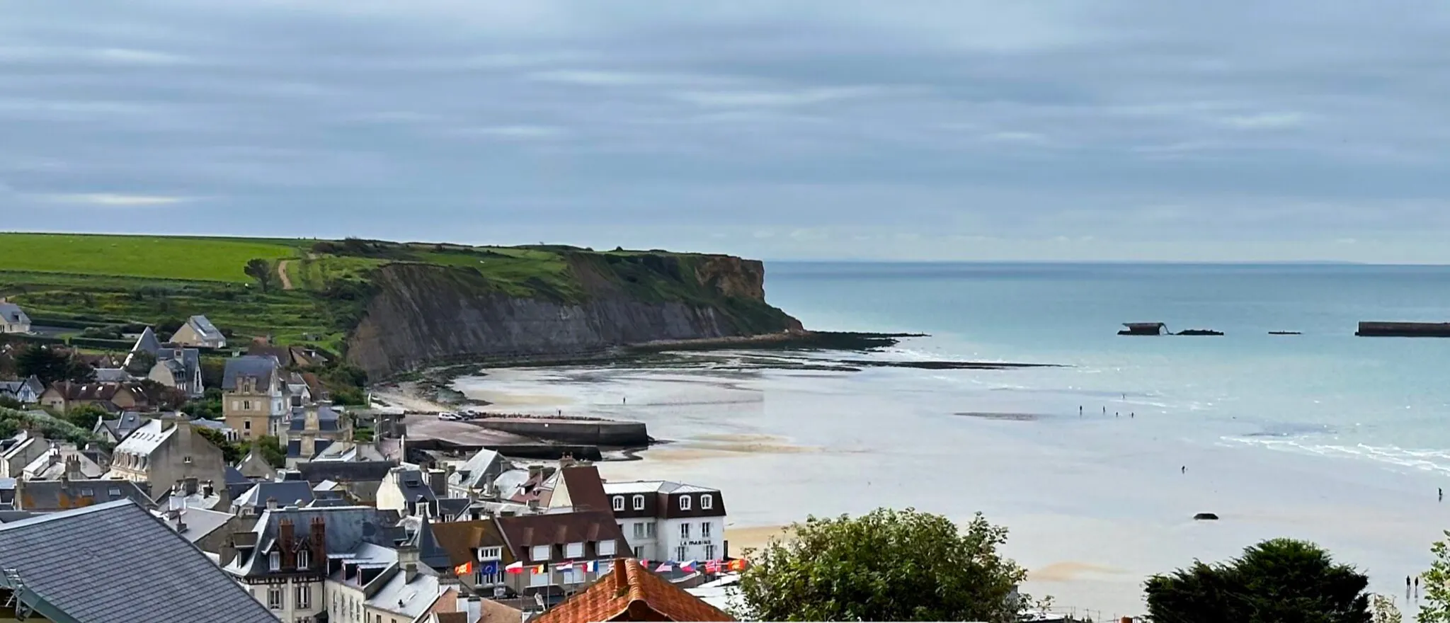
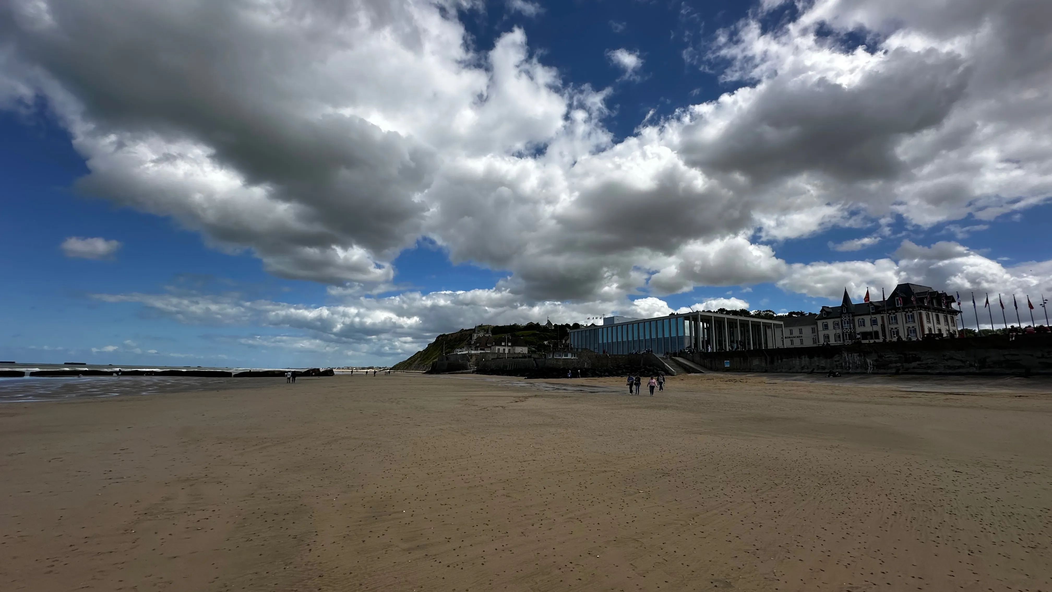
More than eighty years after D-Day, the bay of Arromanches still holds the most spectacular trace of the summer of 1944: the concrete caissons of the Mulberry B artificial harbour, still lined up offshore and on the foreshore. At low tide, you can quite literally walk through an open-air historic site. Here is the story of the harbour nicknamed "Port Winston" — and our advice for seeing it at its best.
Why build an artificial harbour in 1944?
To liberate Western Europe, the Allies had to land and then keep hundreds of thousands of men supplied: fuel, ammunition, food, vehicles. Yet the deep-water ports — Cherbourg, Le Havre — were heavily defended, and the Dieppe raid of 1942 had shown the cost of a frontal assault on a port held by the occupier.
The solution chosen was radical: if you cannot capture a port, you bring one with you. Two artificial harbours were built in sections in Britain, in the utmost secrecy, then towed across the Channel: Mulberry A for the American sector, off Saint-Laurent-sur-Mer (Omaha Beach), and Mulberry B for the British sector, in the bay of Arromanches, at the western end of Gold Beach. The first sections arrived as early as the evening of 6 June 1944.
How did Mulberry B work?
The Arromanches harbour was an assembly of several complementary systems:
- The "Gooseberry" blockships: old vessels deliberately scuttled to form a first breakwater, within days of the landings.
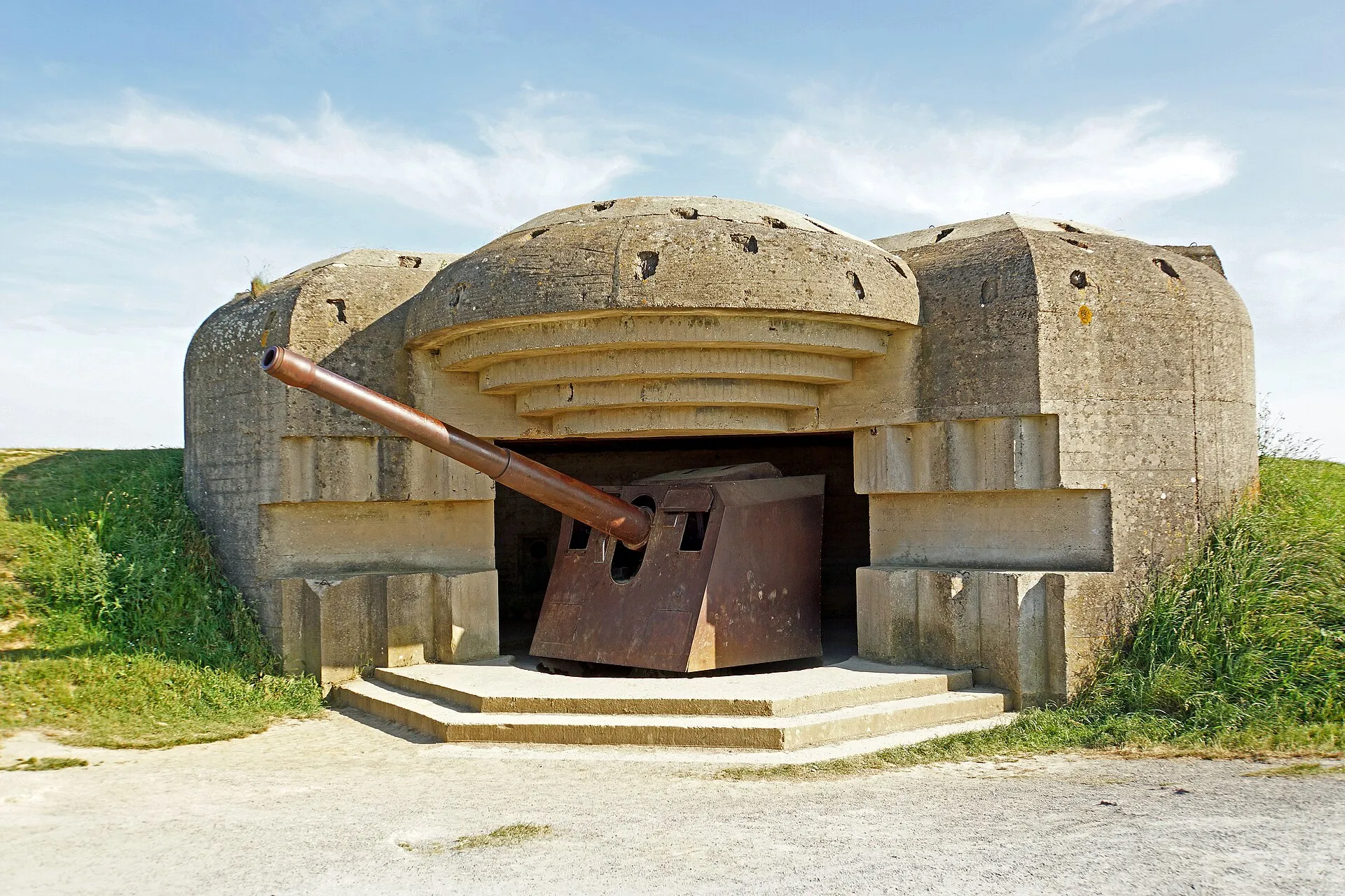
- The "Phoenix" caissons: enormous reinforced-concrete caissons — the largest measure around 60 metres long and 20 metres high — towed over from England, then sunk in an arc to create a sheltered anchorage. Many were topped with an anti-aircraft defence platform. The Arromanches breakwater counted more than a hundred of them.
- The floating "Bombardon" breakwaters, anchored further out to dampen the swell.
- The "Whale" floating piers: metal roadways set on floats, linked to piled jetties (Lobnitz platforms) able to slide up and down to follow the tide — a crucial detail on a coast where the tidal range exceeds several metres.
Cargo ships berthed at the piers and lorries sped towards the front along the piers: a complete harbour, created from scratch in a matter of weeks in front of a fishing village.
The June 1944 storm and the birth of "Port Winston"
From 19 to 22 June 1944, a violent storm swept the Channel. Mulberry A, off Omaha Beach, was destroyed and never returned to service. Mulberry B, better sheltered by the rocks of the Calvados coast, was damaged but repairable: it carried on alone, reinforced with parts salvaged from its American twin.
The Arromanches harbour operated until 19 November 1944. At the height of summer, around 20,000 tonnes of supplies passed through it each day. It was in tribute to Winston Churchill, who had backed the project, that the harbour earned its nickname of Port Winston. To see animated models of the whole system and archive films from the summer of 1944, the Arromanches D-Day Museum, rebuilt in 2023 facing the bay, remains the best introduction.
What is left of the harbour today?
Far more than you might imagine. Underwater archaeology surveys carried out off Arromanches have recorded close to a hundred Phoenix caissons still in place — some of them in good condition —, blockships and a Lobnitz platform. You can consult the file devoted to the D-Day wrecks on the French Ministry of Culture website.
From the beach, you can always make out the line of caissons offshore, still tracing the arc of the old anchorage. And at low tide, several sections stranded on the foreshore become reachable on foot — cracked masses of concrete, gnawed by seaweed and barnacles, striking at close range.
When and how to see the caissons at low tide?
A few pointers to make the most of it:
- Aim for low tide, ideally during the spring tides (high tidal coefficients): the foreshore is then exposed to its maximum and you can get as close as possible to the remains. Check the official tide times on the SHOM website before you come.
- The best viewpoints: the beach itself, of course, but also the eastern cliff of Arromanches, near the circular cinema, from where the full arc of the harbour reveals itself. The coastal path above Arromanches offers several remarkable lookouts, especially late in the day when the light rakes across the bay.
- The light: early in the morning or at sunset, the caissons stand out beautifully against the sea — photographers will love it.
- Safety and respect for the site: the sea comes back in quickly over the foreshore; keep an eye on the tide times, do not climb on the remains and take nothing away. These blocks are fragile historic witnesses, not climbing rocks.
Gold Beach: what to see around Arromanches?
Arromanches lies at the western end of Gold Beach, one of the two British beaches of 6 June 1944, which stretches towards Asnelles and Ver-sur-Mer. Following the coast eastward, you reach Courseulles-sur-Mer and Juno Beach, the Canadian sector; westward, the harbour of Port-en-Bessin, liberated by the Royal Marines in the days that followed D-Day. Our article on Courseulles, Juno Beach and Port-en-Bessin will help you put together an itinerary along these D-Day beaches — the Longues-sur-Mer battery and Bayeux round off the day nicely.
Sleep facing Port Winston
To catch the caissons at the right tide and in the right light, nothing beats staying on the spot: our studio in Arromanches puts you a few minutes' walk from the beach and the remains. In the morning, before the day's visitors arrive, you will have the bay — and the history — almost to yourself.